Pecatu Limestone Sinkhole Surveys Insurance Costs Bali
The Hidden Ground Beneath Pecatu’s Premium Real Estate: Why Limestone Karst Sinkhole Surveys Are Non-Negotiable
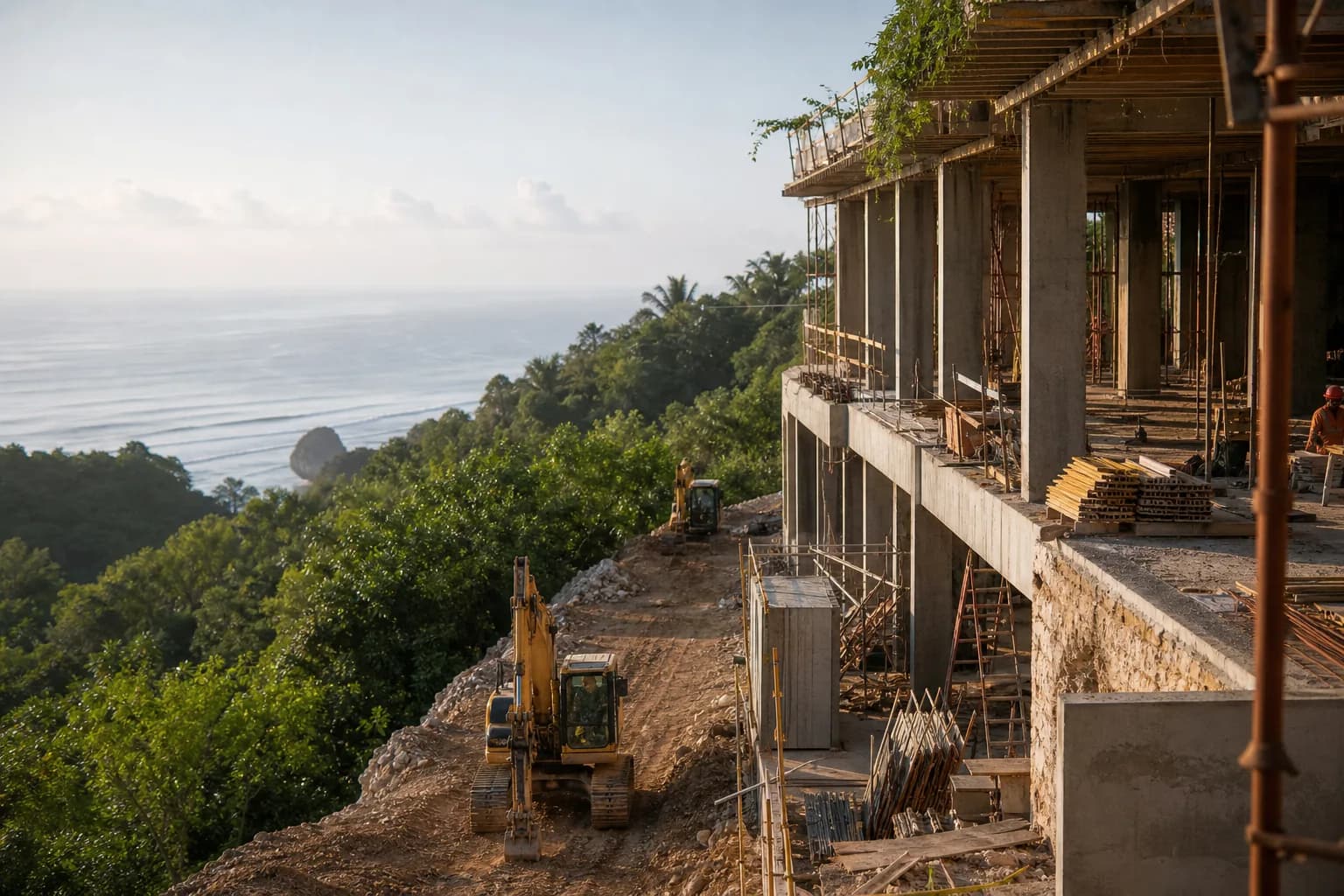
Pecatu’s dramatic clifftop geography and proximity to Uluwatu’s limestone formations create exceptional villa sites—and exceptional subsurface risks. The same karst topography that produces Bali’s iconic cave temples and underground river systems also generates unpredictable void spaces beneath seemingly solid ground. A 2025 BRIN geological survey identified 47 documented sinkhole events across Bali’s southern limestone belt since 2018, with Pecatu’s porous karst geology presenting elevated collapse risk during monsoon saturation cycles. For construction projects on Pecatu land, the question isn’t whether to conduct limestone karst sinkhole surveys—it’s how comprehensive those surveys must be to satisfy both structural engineering requirements and liability insurance underwriting standards that now explicitly exclude karst-related subsidence from standard policies.
Technical Deep Dive: Pecatu Karst Geology and Survey Methodology Requirements
Pecatu sits atop the Bukit Peninsula’s raised coral limestone platform, formed during Pleistocene marine regression approximately 125,000 years ago. This coralline limestone exhibits classic karst characteristics: high primary porosity (15-25%), extensive secondary dissolution channels, and subsurface void networks ranging from centimeter-scale fissures to multi-meter caverns. Unlike competent bedrock, karst limestone undergoes continuous chemical weathering as slightly acidic groundwater dissolves calcium carbonate, progressively enlarging void spaces until structural collapse occurs.
Standard geotechnical boring programs—typically 3-5 boreholes to 10-15 meter depth—prove inadequate for karst terrain. Conventional SPT (Standard Penetration Test) drilling can pass directly between void spaces, providing false confidence in ground conditions. A 2024 structural failure case in Ungasan (8 kilometers north of Pecatu) involved a villa foundation that collapsed into a 4-meter subsurface cavity located just 2.3 meters from the nearest geotechnical borehole. The cavity went undetected because traditional boring spacing (15-20 meter grid) cannot reliably intercept karst voids with irregular three-dimensional geometry.
Comprehensive karst sinkhole surveys for Pecatu construction sites now require multi-method geophysical investigation:
- Ground Penetrating Radar (GPR): 100-400 MHz antenna frequencies penetrate 8-15 meters in limestone, mapping subsurface discontinuities and void spaces. GPR survey grids at 2-meter line spacing provide continuous subsurface imaging rather than point-source boring data. Effective for detecting air-filled or partially saturated voids; limited effectiveness in fully water-saturated conditions below water table.
- Electrical Resistivity Tomography (ERT): Multi-electrode arrays measure subsurface electrical conductivity variations. Karst voids exhibit high resistivity contrast against surrounding limestone matrix. ERT profiles extend 20-30 meters depth, detecting deeper cavity systems beyond GPR range. Critical for identifying water-filled voids and mapping groundwater flow paths that drive ongoing dissolution.
- Seismic Refraction/MASW: Measures seismic wave velocity through subsurface materials. Intact limestone transmits waves at 2,500-4,500 m/s; fractured karst zones and voids show velocity reductions to 800-1,500 m/s. Particularly effective for mapping lateral extent of weakened zones and identifying competent foundation bearing strata.
- Targeted Confirmation Boring: After geophysical anomaly identification, strategic boreholes with downhole camera inspection verify void presence, measure cavity dimensions, and assess roof stability. Minimum 6-8 boreholes for typical 1,000-1,500 m² villa sites in karst terrain, positioned to intersect geophysical anomalies and establish baseline conditions in apparently competent zones.
The Indonesian National Standard (SNI 8460:2017) for foundation design in karst terrain mandates geophysical survey for sites with known limestone geology, but enforcement remains inconsistent. Pecatu’s rapid development has proceeded largely without comprehensive karst investigation, creating latent liability exposure for property owners, contractors, and insurers. As sinkhole incidents increase—driven by groundwater extraction, monsoon infiltration, and construction vibration—insurance underwriters now require documented karst surveys before issuing liability coverage for Pecatu construction projects.
Hidden Risks: What Standard Due Diligence Misses in Pecatu Karst Terrain
Most land purchase agreements in Pecatu include basic geotechnical reports that satisfy IMB (building permit) submission requirements but fail to address karst-specific risks. These standard reports typically provide soil classification, bearing capacity estimates, and foundation recommendations based on limited boring data—without acknowledging subsurface void potential or long-term stability concerns in dissolution-prone limestone.
The critical gap: temporal risk progression. A karst survey conducted today documents current conditions, but limestone dissolution continues throughout a structure’s lifespan. Void spaces stable under natural conditions may destabilize under construction loading, or develop years later as groundwater chemistry changes. A 2023 insurance claim case in Bingin involved foundation settlement 18 months post-construction when a previously stable cavity roof collapsed during exceptional monsoon rainfall. The property owner’s liability policy excluded karst-related subsidence because the original geotechnical report made no mention of karst geology—despite the site’s obvious limestone substrate.
Another overlooked factor: cumulative impact of adjacent development. Pecatu’s construction boom increases groundwater extraction from limestone aquifers, lowering water tables and removing buoyant support from cavity roofs. Excavation vibration from neighboring projects can trigger collapse in marginally stable voids. Your site may pass comprehensive karst survey today, but adjacent development activities alter subsurface stress conditions. Liability insurance policies increasingly include exclusions for “induced subsidence from third-party activities,” leaving property owners exposed to damage from off-site causes.
The most expensive mistake: proceeding with construction after identifying voids without proper remediation. Some developers treat karst voids as localized foundation obstacles, designing around detected cavities or using deep pile foundations to bypass shallow void zones. This approach ignores progressive dissolution—voids expand over time, and new cavities form. Without comprehensive void grouting or foundation systems designed for ongoing ground loss, structures face long-term settlement risk that no insurance policy will cover once karst conditions are documented but inadequately addressed.
Step-by-Step Process: Conducting Comprehensive Karst Surveys and Securing Liability Coverage
Phase 1: Pre-Purchase Karst Risk Assessment (2-3 weeks)
Before finalizing land acquisition in Pecatu, commission preliminary karst evaluation from geotechnical consultants with specific karst terrain experience. This desktop study reviews regional geology, examines aerial/satellite imagery for surface subsidence indicators (circular depressions, vegetation stress patterns), and analyzes topographic data for drainage anomalies suggesting subsurface void networks. Cost: USD $800-1,500 for preliminary assessment. If karst risk indicators present, make land purchase conditional on acceptable results from comprehensive geophysical survey.
Phase 2: Multi-Method Geophysical Investigation (3-4 weeks)
Engage licensed geophysical survey firm to conduct integrated GPR, ERT, and seismic investigation across entire proposed building footprint plus 15-meter perimeter buffer zone. Survey grid density must achieve 2-meter line spacing for GPR, with ERT profiles at 5-meter intervals. Deliverable: subsurface anomaly map identifying void locations, depth, estimated dimensions, and confidence levels. Reputable firms provide written interpretation linking geophysical signatures to probable karst features versus other subsurface conditions (buried boulders, soil density variations, utility infrastructure).
Phase 3: Targeted Confirmation Drilling (2-3 weeks)
Based on geophysical anomaly locations, execute strategic boring program with minimum 6 boreholes for typical villa sites. Boreholes must intersect identified anomalies and establish baseline conditions in apparently competent zones. Specify downhole camera inspection for all boreholes, with video documentation of cavity encounters. Critical: drilling contract must include cavity grouting capability—if significant voids encountered, immediate grouting prevents water infiltration and progressive enlargement during investigation period.
Phase 4: Foundation Engineering for Karst Conditions (2-3 weeks)
Structural engineer develops foundation system specifically designed for documented karst conditions. Options include: (1) void grouting with controlled low-strength material (CLSM) to fill detected cavities, followed by conventional shallow foundations; (2) deep pile foundations extending through karst zone to competent bearing strata, with pile design accounting for potential future ground loss; (3) reinforced raft foundations with structural capacity to bridge undocumented voids. Foundation design must address both current documented conditions and reasonable future void development scenarios. Engineer provides written certification that design satisfies SNI 8460:2017 karst foundation requirements.
Phase 5: Insurance Underwriting Documentation (3-4 weeks)
Compile comprehensive documentation package for liability insurance underwriting: complete geophysical survey reports, boring logs with downhole video, foundation engineering calculations with karst-specific design provisions, and construction monitoring plan. Indonesian insurance market for karst-terrain construction remains limited—expect to approach 4-6 underwriters before securing coverage. Policies will include karst-related exclusions and sublimits; negotiate specific coverage for “sudden subsidence from undocumented voids” with clear definition of what constitutes adequate investigation. Premium loading for karst terrain: 40-120% above standard construction liability rates.
Phase 6: Construction Monitoring and As-Built Verification (throughout construction)
Insurance policies require ongoing geotechnical observation during excavation and foundation construction. Geotechnical engineer must inspect all excavations for void encounters, document any deviations from anticipated conditions, and certify foundation installation. If additional voids discovered during construction, immediate notification to insurer required—failure to disclose can void coverage. Final as-built certification confirms foundation system installed per karst-specific design, with photographic documentation of all void grouting and foundation elements.
Realistic Cost Ranges and Timeline Expectations for Pecatu Karst Investigation
Comprehensive karst sinkhole survey and insurance documentation for typical 1,000-1,500 m² Pecatu villa site:
- Preliminary karst risk assessment: USD $800-1,500 (2-3 weeks)
- Multi-method geophysical survey (GPR + ERT + seismic): USD $6,500-12,000 depending on site access, terrain complexity, and survey density (3-4 weeks fieldwork + 2 weeks reporting)
- Confirmation boring program (6-8 boreholes to 15m depth with downhole camera): USD $8,000-15,000 including mobilization, drilling, sampling, laboratory testing (2-3 weeks)
- Karst-specific foundation engineering: USD $3,500-6,000 for structural design with karst provisions (2-3 weeks)
- Void grouting (if required): USD $15,000-45,000 depending on void volume and accessibility—highly variable based on actual conditions encountered
- Construction phase geotechnical monitoring: USD $4,000-8,000 for periodic site visits and excavation inspection throughout 8-12 month construction period
Total karst investigation and documentation cost: USD $23,000-48,000 before any required remediation grouting. This represents 3-6% of typical villa construction budget, but prevents catastrophic foundation failure costs (USD $150,000-400,000 for post-construction remediation) and enables liability insurance coverage that would otherwise be unavailable.
Liability insurance premium impact: Standard construction all-risk and third-party liability insurance for Bali villa construction: approximately 0.8-1.2% of construction value. With documented karst conditions, expect premium loading of 40-120%, increasing effective rate to 1.1-2.6% of construction value. For USD $800,000 construction project, karst-related premium increase: USD $2,400-11,200 annually. Policies typically require 3-year minimum term for construction and initial occupancy period.
Frequently Asked Questions: Pecatu Karst Surveys and Insurance
Can I use a standard geotechnical report from a neighboring property instead of conducting my own karst survey?
No. Karst void distribution is highly irregular and unpredictable—subsurface conditions vary dramatically over distances of 10-20 meters. A property 50 meters away may have entirely different void patterns. Insurance underwriters require site-specific investigation for the exact parcel under construction. Additionally, karst conditions evolve over time; a survey conducted 2-3 years ago may not reflect current subsurface stability. Teville’s construction process includes mandatory site-specific geotechnical investigation regardless of available adjacent data, because foundation liability cannot be transferred from neighboring properties.
What happens if karst voids are discovered after construction has started?
Discovery of undocumented voids during construction triggers immediate work stoppage and insurer notification. Depending on void location and severity, remediation options include: localized grouting if void is outside primary foundation footprint, foundation redesign with supplemental deep piles, or in extreme cases, relocating the structure on the par
 3124 m²6 month(s)from 123.000 USD
TALA 8
 3180 m²7 month(s)from 142.000 USD
Vasudeva
 2144 m²11 month(s)from 104.000 USD
Narayana
 3173 m²6 month(s)from 125.000 USD
TALA FOUR
 3104 m²11 month(s)from 99.000 USD
TALA 100

Want to calculate?
 4344 m²16 month(s)from 290.000 USD
Radha
 3127 m²9 month(s)from 177.000 USD
Mukunda
 1from 198.000 USD
Private: Haridas Villas
 164 m²7 month(s)from 79.000 USD
TALA TWO
 172 m²8 month(s)from 120.000 USD
Keshava
164 m²7 month(s)from 79.000 USDPrivate: Haridas Villas, Tegallalang
Start With Real Numbers, Not Guesses
Before buying land or finalizing a design, check the realistic build cost range for your project in Bali.
Our team reviews your inputs and gives a grounded estimate.
Available lands
 1430 m²5 min$ 209862Bali, Klungkung
 18900 m²2 min$ 6912931Bali, Pecatu
 1000 m²10 min$ 280788Bali, Pecatu
 2850 m²15 min$ 315887Bali, Tabanan
 6000 m²30 min$ 55419Bali, Tabanan
 250 m²15 min$ 40025Bali, Munggu
 608 m²15 min$ 310377Bali, Seminyak
 1950 m²7 min$ 150092Bali, Tabanan
 2000 m²5 min$ 1440887Bali, Pecatu
 1230 m²15 min$ 132543Bali, Tegallalang
 1000 m²10 min$ 184729Bali, Kutuh South Bali
 770 m²5 min$ 163578Bali, Kedungu
 29000 m²6 min$ 3857143Bali, Tabanan
 300 m²55 min$ 32475Bali, Tegelalang
 2200 m²15 min$ 508005Bali, Canggu
Planning a build in Bali?
Get a feasibility view, budget range and timeline from Teville.
Related guides

Concealed HVAC Duct Sealing QA Finish Repair Protocols Bali
Expert technical guide: Concealed HVAC Duct Sealing QA Finish Repair Protocols Bali
8 min read
Soft-Close Kitchen Hinge Failures in Bali: Quality Issues
Discover why modular kitchen cabinet soft-close hinges fail in Bali. Learn about quality risks, durability issues, and solutions for homeowners.
10 min read
Built-In Wardrobe Installation Termite Protection in Bali
Learn effective termite protection methods for custom built-in wardrobes in Bali. Expert installation tips to safeguard your furniture from pest damage.
10 min read