Pecatu Limestone Karst Subsidence Risk Insurance Bali
Pecatu Limestone Karst Subsidence Risk Assessment & Insurance Costs Bali
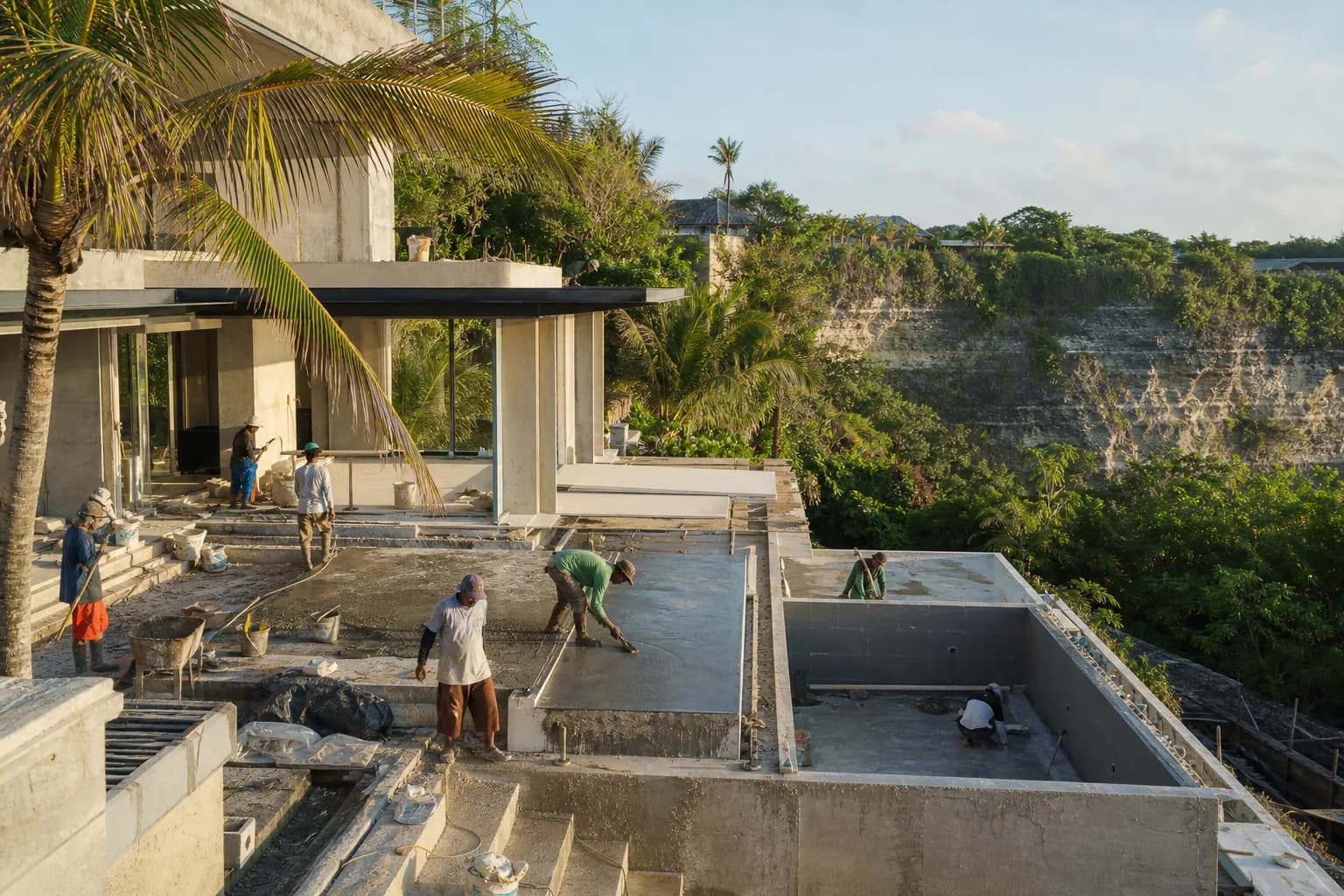
Pecatu’s dramatic clifftop geography and limestone plateau formations create one of Bali’s most visually stunning construction environments—and one of its most geologically complex. As of February 2026, BRIN (Indonesia’s National Research and Innovation Agency) has issued specific warnings about sinkhole risks in limestone regions across Indonesia, with Pecatu’s karst topography presenting measurable subsidence hazards that directly impact construction feasibility, structural engineering requirements, and property insurance availability. For developers and villa buyers in areas like Uluwatu, Bingin, and Padang Padang, understanding limestone dissolution mechanics, cavity detection protocols, and the actual insurance cost implications isn’t optional—it’s the difference between a structurally sound investment and catastrophic foundation failure that no policy will cover.
Karst Geology and Subsidence Mechanics in Pecatu’s Limestone Formation
Pecatu sits on the Bukit Peninsula’s raised limestone plateau, formed from ancient coral reef deposits elevated during tectonic activity. This calcium carbonate-rich geology creates classic karst topography characterized by underground drainage systems, dissolution cavities, and unpredictable void formation beneath seemingly stable surface terrain.
The Dissolution Process and Cavity Formation
Limestone subsidence in Pecatu occurs through carbonic acid dissolution—rainwater absorbing atmospheric CO2 creates weak carbonic acid that slowly dissolves calcium carbonate rock. In tropical Bali’s high-rainfall environment (2,000-3,000mm annually in southern regions), this process accelerates significantly compared to temperate karst regions. Underground water flow creates preferential dissolution pathways, forming cavities ranging from small voids (0.5-2 meters) to substantial caverns (5-15 meters diameter) at depths between 3-25 meters below surface grade.
The critical engineering concern isn’t the dissolution itself—it’s the unpredictable timing of cavity roof collapse. A subsurface void may remain stable for decades until additional loading (construction weight), vibration (pile driving), or hydrological changes (altered drainage from development) trigger sudden failure. Recent geotechnical investigations in Pecatu have identified cavity presence in approximately 18-24% of surveyed parcels, with higher concentrations in areas with historical sinkhole events near Padang Padang and southern Bingin.
Subsidence Risk Classification for Construction Sites
Professional karst hazard assessment categorizes Pecatu sites into four risk levels based on geological surveys, ground-penetrating radar (GPR), and electrical resistivity tomography (ERT) data:
- Low Risk (15-20% of surveyed areas): Solid limestone bedrock within 3-5 meters, no detected voids to 20-meter depth, minimal surface fracturing. Standard foundation engineering with enhanced monitoring protocols.
- Moderate Risk (35-40% of areas): Detected voids at 8-15 meter depths, stable cavity geometry, no active subsidence indicators. Requires specialized foundation design (deep piles bypassing void zones, reinforced raft foundations) and ongoing settlement monitoring.
- High Risk (25-30% of areas): Multiple cavity systems, evidence of historical subsidence (surface depressions, tilted vegetation, fractured rock outcrops), active dissolution indicators. Demands comprehensive ground improvement (cavity grouting, soil stabilization) before construction feasibility determination.
- Extreme Risk (10-15% of areas): Known sinkhole locations, active subsidence zones, unstable cavity roof conditions. Generally unsuitable for permanent structure construction without prohibitively expensive ground treatment (often exceeding land purchase cost).
Insurance Industry Response to Karst Subsidence
Indonesian property insurance providers have significantly tightened underwriting criteria for Pecatu limestone areas following several high-profile subsidence claims between 2022-2025. Standard property insurance policies now explicitly exclude karst-related subsidence unless specific geological surveys are provided and premium adjustments applied. International insurers serving high-value villa properties require comprehensive geotechnical reports meeting specific technical standards before policy issuance—and many simply decline coverage for properties in documented high-risk zones regardless of premium offered.
Hidden Risks Buyers and Developers Consistently Overlook
The most dangerous assumption in Pecatu construction is equating surface stability with subsurface integrity. A perfectly flat, vegetation-covered parcel may conceal substantial void networks that only become apparent during excavation—or worse, years after construction completion when progressive cavity enlargement triggers sudden collapse.
The Pre-Purchase Investigation Gap
Approximately 70% of land transactions in Pecatu proceed without adequate subsurface investigation. Buyers conduct topographic surveys, legal due diligence, and IMB permit research, but skip the critical geotechnical assessment that reveals actual construction feasibility. This creates a scenario where land purchase completes at market rates (USD $400-800/m² in prime clifftop areas), only for subsequent geological surveys to reveal subsidence risks requiring $150,000-300,000 in ground improvement—costs that weren’t factored into project budgets or feasibility calculations.
The Insurance Availability Shock
Many developers discover insurance limitations only after construction completion when attempting to secure property coverage. Without pre-construction geological documentation proving low subsidence risk, insurers either decline coverage entirely or offer policies with karst subsidence exclusions—rendering the property effectively uninsurable for its primary structural risk. For leasehold villa operations targeting international rental markets, this insurance gap creates immediate operational problems as management companies and booking platforms increasingly require comprehensive property insurance as participation prerequisites.
The Progressive Risk Factor
Karst subsidence risk isn’t static—it increases with area development density. Each new construction project alters surface drainage patterns, concentrates water flow into new pathways, and potentially accelerates dissolution in adjacent parcels. A site assessed as low-risk in 2024 may shift to moderate-risk by 2027 as surrounding development changes hydrological conditions. This progressive risk elevation affects long-term property values and insurance renewability in ways initial assessments don’t capture.
Professional Subsidence Risk Assessment Protocol for Pecatu Sites
Comprehensive karst hazard evaluation for construction sites follows a structured investigation sequence that progressively narrows risk uncertainty through multiple technical methodologies.
Phase 1: Desktop Geological Review (Week 1)
Compile existing geological data including regional karst mapping, historical sinkhole records, aerial photography analysis for surface depression indicators, and hydrological flow pattern assessment. Review adjacent property geotechnical reports if available through professional networks. This desktop phase identifies preliminary risk classification and determines appropriate field investigation scope.
Phase 2: Surface Geological Mapping (Week 1-2)
Conduct detailed site walkover documenting surface karst features: rock outcrops, fracture patterns, vegetation anomalies indicating subsurface voids (circular depressions with altered plant growth), drainage sinks, and any historical subsidence evidence. Professional geological mapping typically costs $2,500-4,500 for standard villa parcels (1,000-2,000m²) and provides essential context for interpreting subsequent geophysical data.
Phase 3: Geophysical Subsurface Investigation (Week 2-3)
Deploy ground-penetrating radar (GPR) and electrical resistivity tomography (ERT) to detect subsurface voids without invasive drilling. GPR effectively identifies shallow cavities (0-8 meters depth) with 0.3-0.5 meter resolution, while ERT provides deeper penetration (15-25 meters) with lower resolution but better cavity volume estimation. Combined geophysical survey for typical villa sites costs $8,000-15,000 depending on terrain complexity and required investigation depth. This phase identifies specific void locations, approximate dimensions, and depth to stable bedrock.
Phase 4: Confirmatory Borehole Investigation (Week 3-4)
Execute targeted drilling program at locations indicated by geophysical surveys to physically confirm cavity presence, measure void dimensions, assess roof stability, and obtain rock core samples for strength testing. Minimum 4-6 boreholes to 15-20 meter depths provides adequate spatial coverage for villa construction sites. Borehole investigation costs $1,200-1,800 per hole including mobilization, drilling, sampling, and laboratory testing—total phase cost typically $6,000-12,000.
Phase 5: Engineering Risk Analysis and Mitigation Design (Week 4-5)
Integrate all investigation data into comprehensive geotechnical report with specific subsidence risk classification, foundation engineering recommendations, and ground improvement requirements if needed. For moderate-risk sites, this may specify deep pile foundations extending to stable rock below void zones, reinforced raft foundations distributing loads across larger areas, or cavity grouting to fill detected voids with controlled low-strength material. Engineering analysis and report preparation costs $4,000-7,000 from qualified geotechnical consultants.
Phase 6: Insurance Documentation Package (Week 5-6)
Prepare insurance-specific documentation package including executive summary of findings, risk classification statement, foundation design specifications addressing identified hazards, and professional engineer certification. This package becomes essential for securing property insurance and typically requires $1,500-2,500 in additional documentation preparation beyond standard geotechnical reporting.
Total professional subsidence risk assessment for Pecatu villa sites: $22,000-42,000 depending on site complexity, investigation depth requirements, and detected risk levels requiring additional analysis. This represents 3-6% of typical villa construction budgets but provides the foundational data determining project feasibility and long-term structural viability.
Realistic Cost Implications: Assessment, Mitigation, and Insurance
Ground Improvement Costs for Moderate-Risk Sites
When geotechnical investigation reveals subsurface voids requiring treatment before construction, ground improvement costs vary significantly based on cavity depth, volume, and accessibility:
- Cavity grouting (void filling): $180-320 per cubic meter of void volume, with typical moderate-risk sites requiring 40-120m³ treatment = $7,200-38,400
- Deep pile foundations bypassing void zones: Additional $25,000-65,000 beyond standard foundation costs for typical 300m² villa footprint
- Reinforced raft foundation systems: Premium of $180-280/m² over standard foundations = $54,000-84,000 for 300m² building area
- Ongoing settlement monitoring systems: $8,000-15,000 for automated monitoring with quarterly reporting over 2-year post-construction period
Insurance Premium Structure for Karst-Risk Properties
Property insurance costs in Pecatu vary dramatically based on documented subsidence risk and mitigation measures implemented:
- Low-risk sites (documented through professional assessment): Standard premium rates of 0.35-0.55% of insured value annually, with karst subsidence coverage included. For $800,000 villa: $2,800-4,400 annual premium.
- Moderate-risk sites (with engineered mitigation): Premium rates increase to 0.65-0.95% with specific karst subsidence sub-limits (typically 50-70% of total insured value) and higher deductibles ($15,000-25,000 for subsidence claims). For $800,000 villa: $5,200-7,600 annual premium.
- High-risk sites (limited mitigation feasibility): Most insurers decline comprehensive coverage; available policies exclude karst subsidence entirely or offer coverage at 1.4-2.1% premium rates with severe sub-limits. For $800,000 villa: $11,200-16,800 annual premium for partial coverage.
- Undocumented sites (no geological assessment): Increasing number of insurers require geotechnical documentation as underwriting prerequisite; policies issued without assessment typically include blanket karst subsidence exclusions regardless of actual site conditions.
Timeline Considerations
Comprehensive subsidence risk assessment adds 5-6 weeks to pre-construction timeline but prevents far more significant delays from mid-construction geological surprises or post-construction insurance procurement failures. Ground improvement work (if required) adds 3-6 weeks to construction schedule depending on treatment scope and weather conditions affecting grouting operations.
Frequently Asked Questions: Pecatu Karst Subsidence and Insurance
Can I skip the geological survey if neighboring properties show no subsidence issues?
No—karst cavity distribution is highly localized and unpredictable. Properties separated by 50-100 meters can have dramatically different subsurface conditions due to preferential dissolution pathways following specific fracture networks and underground drainage routes. Adjacent stable properties provide no reliable indication of your site’s subsurface integrity. Additionally, insurance underwriters require site-specific geological documentation; neighboring property assessments hold no value for your coverage application. The $25,000-40,000 investigation cost is non-negotiable risk management for any serious Pecatu construction project.
What happens if subsidence occurs after construction on a site that passed geological assessment?
Professional geotechnical assessments include limitation statements acknowledging that subsurface investigation samples discrete locations and cannot guarantee absolute absence of all voids across entire parcels. However, properly conducted assessments meeting insuranc
 3173 m²6 month(s)from 125.000 USD
TALA FOUR
 164 m²7 month(s)from 79.000 USD
Private: Haridas Villas, Tegallalang
 3104 m²11 month(s)from 99.000 USD
TALA 100
 1from 198.000 USD
Private: Haridas Villas
 3180 m²7 month(s)from 142.000 USD
Vasudeva
 3124 m²6 month(s)from 123.000 USD
TALA 8
164 m²7 month(s)from 79.000 USDTALA TWO
 3127 m²9 month(s)from 177.000 USD
Mukunda
 4344 m²16 month(s)from 290.000 USD
Radha
 172 m²8 month(s)from 120.000 USD
Keshava
 2144 m²11 month(s)from 104.000 USD
Narayana

Want to calculate?
Start With Real Numbers, Not Guesses
Before buying land or finalizing a design, check the realistic build cost range for your project in Bali.
Our team reviews your inputs and gives a grounded estimate.
Available lands
 7250 m²56 min$ 235714Bali, Tabanan
 29000 m²6 min$ 3857143Bali, Tabanan
 1375 m²10 min$ 447044Bali, Canggu
 3100 m²15 min$ 257697Bali, Tegallalang
 2500 m²5 min$ 609606Bali, Kedungu
 2130 m²10 min$ 495776Bali, Pecatu
 2200 m²15 min$ 508005Bali, Canggu
 2000 m²15 min$ 110837Bali, Karangasem
 680 m²15 min$ 110751Bali, Pererenan
 444 m²10 min$ 111000Bali, Tabanan
 700 m²7 min$ 400000Bali, Canggu
 2800 m²2 min$ 713793Bali, Kedungu
 1700 m²10 min$ 632257Bali, Kuta
 1000 m²10 min$ 384852Bali, Canggu
 2850 m²15 min$ 315887Bali, Tabanan
Planning a build in Bali?
Get a feasibility view, budget range and timeline from Teville.
Related guides

Concealed HVAC Duct Sealing QA Finish Repair Protocols Bali
Expert technical guide: Concealed HVAC Duct Sealing QA Finish Repair Protocols Bali
8 min read
Soft-Close Kitchen Hinge Failures in Bali: Quality Issues
Discover why modular kitchen cabinet soft-close hinges fail in Bali. Learn about quality risks, durability issues, and solutions for homeowners.
10 min read
Built-In Wardrobe Installation Termite Protection in Bali
Learn effective termite protection methods for custom built-in wardrobes in Bali. Expert installation tips to safeguard your furniture from pest damage.
10 min read