Jimbaran Bay Flood Insurance Elevation Costs Bali
Why Jimbaran Bay Properties Face Unique Tidal Flood Insurance Challenges
Jimbaran Bay’s crescent-shaped coastline creates a distinctive tidal pattern that directly impacts flood insurance premiums and construction elevation requirements. Properties within 300 meters of the high-tide line face annual insurance costs ranging from $1,200 to $2,800, with elevation certificates becoming mandatory for structures below the 3.5-meter datum line. The bay’s gradual slope and seasonal monsoon surge patterns create flood zones that Indonesian insurance providers classify differently than standard coastal areas, requiring specialized engineering documentation that most villa buyers discover only after land purchase.
Engineering Analysis: Jimbaran Bay’s Tidal Flood Risk Profile
Jimbaran Bay’s flood risk stems from three converging factors: astronomical tides averaging 2.1 meters during spring cycles, seasonal southwest monsoon surge adding 0.8-1.2 meters of water elevation, and the bay’s shallow bathymetry that amplifies wave run-up during storm events. The Indonesian Geospatial Agency (BIG) classifies the southern Jimbaran coastline as Zone 3 flood risk, while northern sections near the fish market fall into Zone 4—the highest coastal risk category.
From a construction engineering perspective, these classifications translate directly to foundation design requirements. Properties in Zone 3 require minimum finished floor elevations of 3.5 meters above mean sea level (MSL), while Zone 4 properties need 4.2 meters minimum. This isn’t merely regulatory compliance—it’s structural necessity. During the 2016 monsoon season, properties with finished floors below 3.0 meters experienced water intrusion, while those engineered to 3.8+ meters remained dry despite identical proximity to the shoreline.
The elevation certificate process in Jimbaran requires a licensed Indonesian surveyor (PBJ-certified) to establish your property’s base flood elevation (BFE) relative to the national vertical datum. This survey costs between $450-$750 and takes 5-7 working days, but it’s the foundation of your insurance premium calculation. Properties that can demonstrate finished floor elevations exceeding BFE by 0.5 meters or more qualify for reduced premiums—typically 18-25% lower than baseline rates.
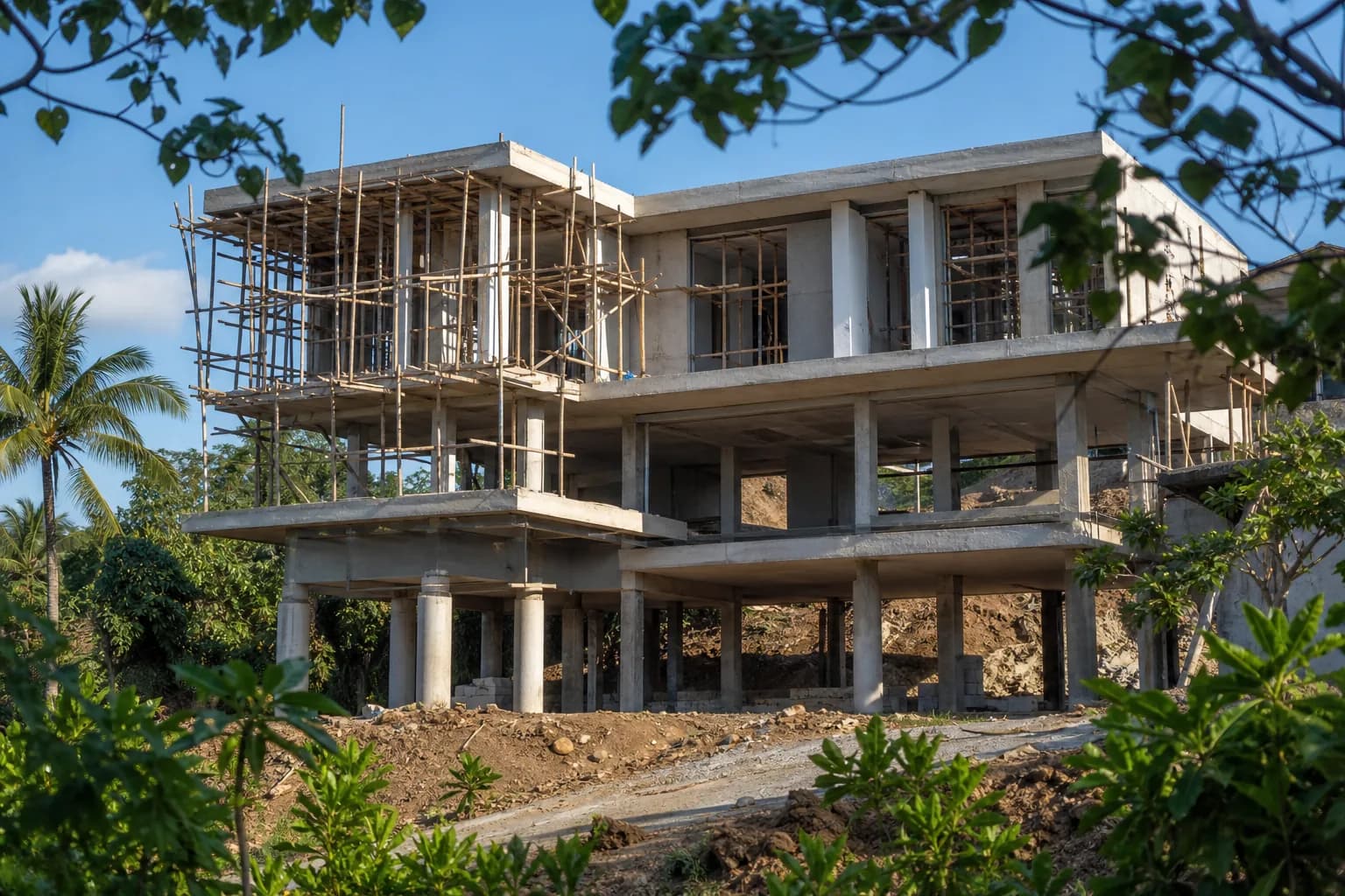
Teville’s approach to villa construction in Jimbaran Bay begins with topographic analysis before land purchase. We map existing grade elevations, calculate cut-and-fill requirements to achieve target finished floor heights, and model drainage patterns to prevent water accumulation during 100-year storm events. This engineering-first methodology prevents the costly scenario where buyers purchase low-lying land, then discover that achieving compliant elevation requires an additional $35,000-$55,000 in earthwork and retaining structures.
The structural implications extend beyond foundation height. Elevated structures in tidal zones require reinforced pile foundations extending 4-6 meters below grade to reach stable soil layers beneath the water table. Standard shallow foundations used in inland Bali locations are structurally inadequate for coastal Jimbaran properties. The engineering specification difference adds $180-$240 per square meter to foundation costs, but eliminates the risk of differential settlement that causes cracking, door misalignment, and structural distress in improperly engineered coastal villas.
Indonesian flood insurance providers—primarily Asuransi Jasindo and Asuransi Sinar Mas—calculate premiums using a matrix of elevation differential, construction materials, and distance from tidal influence. A villa with finished floor at +4.0 meters MSL, located 250 meters from high-tide line, constructed with reinforced concrete, typically pays $1,400-$1,650 annually for $500,000 coverage. The identical structure at +3.2 meters elevation pays $2,200-$2,600 for the same coverage—a 57% premium increase driven purely by elevation deficiency.
Hidden Risks: What Elevation Certificates Don’t Reveal
The standard elevation certificate documents your structure’s height relative to base flood elevation, but it doesn’t capture subsurface drainage capacity—a critical factor in Jimbaran’s coral limestone geology. Properties built on reclaimed or filled land experience different drainage characteristics than those on natural grade. We’ve documented cases where two adjacent properties with identical elevation certificates experienced vastly different flood performance because one was constructed on 2.5 meters of imported fill with inadequate compaction and no subsurface drainage system.
Another overlooked factor: elevation certificates measure finished floor height, but insurance claims are triggered by water intrusion at any building envelope penetration. Ground-level utility rooms, basement storage areas, and sunken garden features below the certified elevation create insurance coverage gaps. Insurers may deny claims for damage to below-grade spaces even when the primary structure remains above flood levels. Proper engineering design eliminates below-grade spaces in flood-prone zones or specifies waterproof construction with sump pump systems—adding $8,000-$12,000 to construction costs but preserving full insurance coverage.
The temporal dimension of flood risk is rarely discussed. Jimbaran Bay’s tidal patterns are shifting measurably due to coastal development and climate factors. Properties that achieved comfortable elevation margins in 2015 now sit closer to threshold levels. Forward-looking construction design should target elevation margins of 0.8-1.0 meters above current BFE requirements, not the minimum 0.3-meter margin that satisfies today’s insurance underwriters but may prove inadequate within a 15-year ownership horizon.
Step-by-Step Process: Securing Optimal Insurance Rates Through Engineering
Phase 1: Pre-Purchase Elevation Assessment (Week 1-2)
Before committing to land purchase in Jimbaran Bay, commission a preliminary topographic survey from a PBJ-certified surveyor. This $300-$450 investment maps existing grade elevations across the property and identifies the lowest point—critical for calculating earthwork requirements. Request the surveyor to reference the national vertical datum (not relative elevations) so results are directly comparable to BIG flood zone maps. Cross-reference your property’s coordinates with the official flood zone designation available through the Badung Regency spatial planning office (Dinas PUPR).
Phase 2: Engineering Feasibility Analysis (Week 3-4)
With topographic data and flood zone classification confirmed, engage a structural engineer to model foundation options. For Jimbaran Bay properties, this analysis should evaluate: pile foundation depth requirements based on soil boring data, finished floor elevation targets that exceed BFE by minimum 0.5 meters, cut-and-fill earthwork volumes to achieve target grades, and retaining wall requirements if significant grade changes are necessary. Teville provides this analysis as part of our preliminary cost estimation service, integrating flood risk mitigation into the initial design phase rather than treating it as an afterthought.
Phase 3: Formal Elevation Certificate (Week 5-6)
Once construction design is finalized, obtain the formal elevation certificate that will be submitted to insurance underwriters. This document must show: lowest adjacent grade (LAG) elevation, highest adjacent grade (HAG) elevation, lowest floor elevation including attached garage or utility spaces, and elevation of mechanical equipment (HVAC, water pumps, electrical panels). The certificate remains valid for the structure’s lifetime unless substantial improvements exceeding 50% of the building’s value are made, triggering recertification requirements.
Phase 4: Insurance Underwriting Submission (Week 7-8)
Submit elevation certificate, construction specifications, and site drainage plans to minimum three Indonesian insurance providers for competitive quotes. Premium variations of 30-40% between providers are common for identical properties. Ensure quotes specify: coverage limits for structure and contents separately, deductible amounts (typically 2-5% of coverage amount), exclusions for below-grade spaces, and premium adjustment triggers. Request multi-year rate locks if available—some providers offer 3-year fixed premiums with 8-12% total cost savings versus annual renewals.
Phase 5: Construction Monitoring & Final Certification (Months 6-10)
During construction, document foundation elevation with surveyor verification at three stages: post-excavation before concrete pour, post-foundation before framing, and final finished floor before occupancy. This creates an auditable elevation record that insurers may request during claims processing. Final insurance activation requires: completed elevation certificate with surveyor’s stamp, IMB (building permit) completion certificate from Badung Regency, and photographic documentation of finished floor heights relative to permanent benchmarks.
Realistic Cost Ranges: Jimbaran Bay Elevation & Insurance Budget
For a 250-square-meter villa in Jimbaran Bay Zone 3 (moderate coastal risk), budget the following elevation-related costs:
- Preliminary topographic survey: $300-$450 (one-time)
- Formal elevation certificate: $450-$750 (one-time, valid for structure lifetime)
- Additional earthwork to achieve +3.8m elevation: $12,000-$18,000 for properties requiring 1.0-1.5m fill (varies dramatically based on existing grade)
- Upgraded pile foundation system: $45,000-$60,000 versus $28,000-$35,000 for standard inland foundation—premium of $17,000-$25,000
- Subsurface drainage system: $6,500-$9,500 for perimeter drains, sump basin, and discharge pumps
- Annual flood insurance premium: $1,400-$1,650 for properly elevated structure with $500,000 coverage; $2,200-$2,800 for marginally compliant elevation
The total elevation-related construction premium for Jimbaran Bay coastal properties ranges from $36,000-$53,000 compared to identical structures on inland Bali sites. However, this investment reduces annual insurance costs by $800-$1,200 and eliminates flood damage risk that could exceed $150,000 in a single event. The engineering payback period is immediate when viewed through risk-adjusted total cost of ownership.
Timeline expectations: elevation certificate processing requires 5-7 working days after survey completion. Insurance underwriting takes 10-14 days with complete documentation. Construction timeline impact is minimal—proper elevation design adds 3-5 days to earthwork phase but doesn’t extend overall project duration when integrated into initial planning.
Frequently Asked Questions: Jimbaran Bay Flood Insurance Specifics
Do leasehold properties in Jimbaran Bay require flood insurance, or is this only for freehold land?
Insurance requirements are independent of land tenure type. Whether you hold leasehold rights (Hak Sewa) or freehold title (Hak Milik through Indonesian entity), lenders and prudent risk management demand flood insurance for coastal Jimbaran properties. Leasehold agreements often specify insurance as a lessee obligation, with the landowner named as additional insured. The elevation certificate and insurance policy should match the legal entity holding the lease or title—typically your Indonesian PT PMA company. Teville’s verified land consultation service includes insurance requirement analysis specific to each property’s tenure structure.
Can I reduce insurance premiums by installing flood barriers or pumps instead of elevating the structure?
Indonesian flood insurance underwriters offer minimal premium reductions (typically 5-8%) for active flood mitigation systems like barriers or pumps, versus 18-25% reductions for structural elevation exceeding BFE by 0.5+ meters. The reason: mechanical systems require maintenance, power supply, and human activation, creating failure points. Structural elevation is passive protection that functions regardless of power availability or occupant presence. From an engineering perspective, pumps and barriers are supplementary protection for properly elevated structures, not substitutes for adequate foundation height. Budget $4,500-$7,000 for a comprehensive pump system as additional protection, not as an elevation alternative.
What happens to my insurance premium if Jimbaran Bay’s flood zone classification changes?
Flood zone reclassifications trigger premium adjustments at your next renewal period, not mid-policy. BIG updates coastal flood maps every 3-5 years based on tidal monitoring data and development patterns. If your property is reclassified from Zone 3 to Zone 4, expect premium increases of 25-35% unless your elevation certificate demonstrates sufficient margin above the new BFE requirement. This is why Teville recommends designing to elevation targets 0.8-1.0 meters above current minimums—creating buffer against future reclassification. Properties engineered with this margin have maintained stable premiums through two reclassification cycles, while minimum-compliance structures experienced 40-60% premium increases.
Are there specific construction materials that reduce flood insurance costs in Jimbaran Bay?
Yes. Reinforced concrete construction receives 12-18% lower premiums than timber or light steel framing for identical elevation and location. Elevated floor systems (structure on piles with open ground level) receive additional 8-12% discounts versus slab-on-grade construction, even when both achieve identical finished floor elevations. Flood-resistant materials below BFE—such as ceramic tile versus hardwood, concrete versus gypsum board—can reduce premiums by 5-8%. These material specifications should be documented in your insurance application with supporting construction drawings. Our villa project portfolio demonstrates material selections optimized for both structural performance and insurance efficiency in coastal Bali locations.
How does Jimbaran Bay flood insurance differ from standard property insurance in Bali?
Standard Indonesian property insurance (Asuransi Kebakaran) excludes flood damage—it covers fire, earthquake, and wind damage but specifically excludes wat
 2144 m²11 month(s)from 104.000 USD
Narayana
 164 m²7 month(s)from 79.000 USD
TALA TWO
 3173 m²6 month(s)from 125.000 USD
TALA FOUR
 3180 m²7 month(s)from 142.000 USD
Vasudeva
 172 m²8 month(s)from 120.000 USD
Keshava
164 m²7 month(s)from 79.000 USDPrivate: Haridas Villas, Tegallalang
 4344 m²16 month(s)from 290.000 USD
Radha
 1from 198.000 USD
Private: Haridas Villas
 3124 m²6 month(s)from 123.000 USD
TALA 8

Want to calculate?
 3104 m²11 month(s)from 99.000 USD
TALA 100
 3127 m²9 month(s)from 177.000 USD
Mukunda
Start With Real Numbers, Not Guesses
Before buying land or finalizing a design, check the realistic build cost range for your project in Bali.
Our team reviews your inputs and gives a grounded estimate.
Available lands
 13000 m²1 min$ 920567Bali, Pekutatan
 260 m²5 min$ 51872Bali, Kedungu
 1200 m²2 min$ 155172Bali, Klungkung
 422 m²15 min$ 93547Bali, Kerobokan
 515 m²7 min$ 570813Bali, Canggu
 2700 m²30 min$ 314224Bali, Sidemen
 1000 m²5 min$ 350431Bali, Drupadi
 1000 m²10 min$ 123154Bali, Jimbaran
 889 m²15 min$ 145612Bali, Cepaka
 2000 m²15 min$ 110837Bali, Karangasem
 3900 m²10 min$ 432266Bali, Tabanan
 700 m²15 min$ 109052Bali, Buduk
 1430 m²5 min$ 209862Bali, Klungkung
 5000 m²8 min$ 424877Bali, Ungasan
 5028 m²10 min$ 361000Bali, Ubud
Planning a build in Bali?
Get a feasibility view, budget range and timeline from Teville.
Related guides
Recessed Lighting Costs: Concrete vs Bamboo Ceilings Bali
Compare recessed lighting installation costs for concrete and bamboo ceilings in Bali villas. Get accurate pricing and expert tips for your construction project
10 min read
Concrete Batching Plant vs Ready-Mix: Cost Per m³ Bali
Compare concrete batching plant vs ready-mix costs per m³ for Bali construction projects. Expert analysis on pricing, efficiency best options for villas.
10 min read
Split AC Refrigerant Line Limits for Bali Multi-Story Villas
Expert guide to split AC refrigerant line set length limits for Bali villas. MEP specifications, installation best practices, and performance optimization.
11 min read