Seminyak Beachfront Setback Rules Erosion Costs Bali
Seminyak Beachfront Construction: Why 2026 Setback Enforcement Changes Everything
Seminyak’s beachfront zone faces unprecedented regulatory pressure as Bali’s coastal setback enforcement intensifies in 2026. Property owners within 100 meters of the high-tide line now confront demolition orders, penalties exceeding $45,000, and structural removal costs reaching $220,000. Unlike Sanur’s recent crackdown, Seminyak presents compounded challenges: accelerated coastal erosion rates of 2-4 meters annually, saturated groundwater tables affecting foundation stability, and high-density commercial development creating enforcement complexity. For anyone considering building villa Bali projects near Seminyak’s coastline, understanding the intersection of setback compliance and erosion-driven structural risk is no longer optional—it’s the difference between a viable construction investment and a forced demolition scenario.
Engineering Reality: Seminyak’s Coastal Setback Zone and Erosion Mechanics
Seminyak’s 100-meter coastal setback regulation operates differently than other Bali regions due to specific geotechnical and hydrological conditions. The high-tide line measurement point shifts seasonally by 8-15 meters during monsoon periods, creating legal ambiguity for structures built near the boundary. Our construction engineering assessments reveal three critical technical factors:
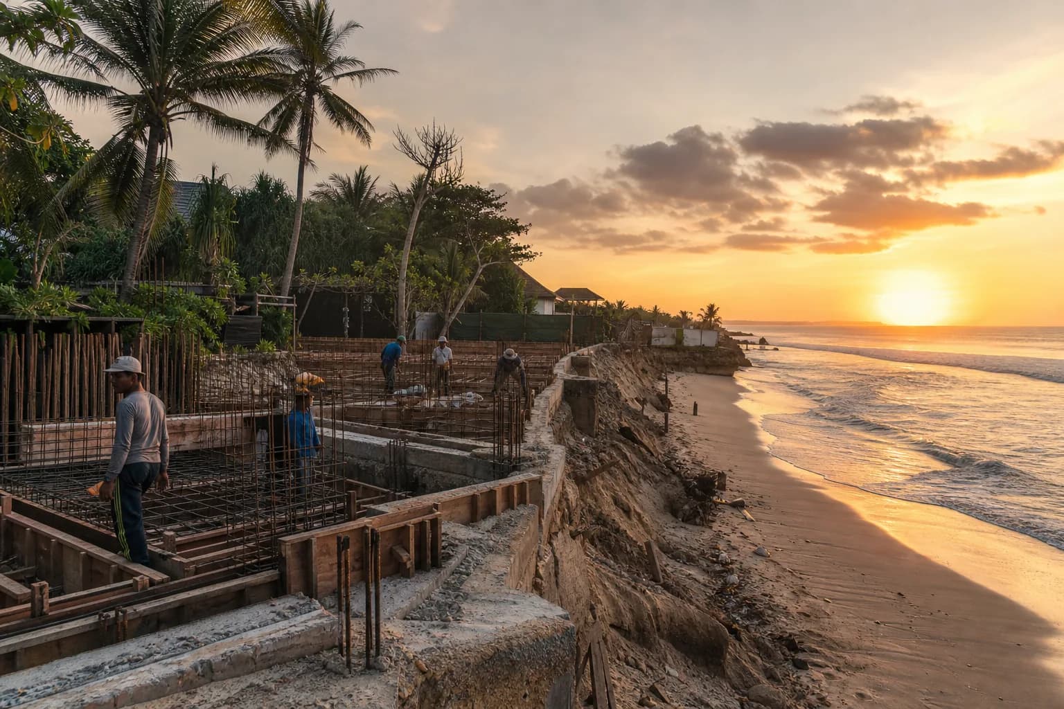
Erosion Rate Variability: Seminyak’s beach sections between Ku De Ta and Potato Head experience 2.8-4.2 meters of annual shoreline retreat, compared to 1.2-1.8 meters in southern Canggu. This acceleration stems from offshore sand mining legacy effects (2008-2014), altered longshore drift patterns from Benoa Harbor expansion, and increased storm surge frequency. Properties initially constructed 120 meters from the waterline in 2015 now sit 85-95 meters from current high-tide markers—placing them within violation range within 36-48 months without intervention.
Foundation Stability in Setback Zones: The 0-100 meter coastal band exhibits groundwater tables 0.8-1.4 meters below surface grade, with salinity levels of 12,000-18,000 ppm—three times higher than inland Seminyak locations. This creates accelerated concrete degradation (reinforcement corrosion rates 40% faster than standard tropical exposure) and requires specialized foundation systems. Standard bored pile foundations experience 15-22% capacity reduction over 10-year periods in this zone. Our construction methodology for coastal-adjacent projects mandates marine-grade concrete (minimum C35 with silica fume), epoxy-coated reinforcement, and pile depths extending 2.5 meters below the freshwater lens boundary.
Regulatory Measurement Protocols: Bali’s Coastal and Marine Resources Management Agency (BPSPL) now uses differential GPS surveying to establish high-tide lines, replacing visual estimation methods. The 100-meter setback applies perpendicular from this surveyed line, not from existing seawalls or erosion control structures. Properties with private seawalls face double jeopardy: the setback measures from the natural shoreline position (as if the seawall didn’t exist), and the seawall itself may constitute an illegal coastal structure requiring removal. We’ve documented cases where seawall construction inadvertently placed the main villa structure into violation status by altering the legal measurement baseline.
Enforcement Prioritization Pattern: February 2026 enforcement actions in Seminyak target three categories: (1) structures built after 2019 within 75 meters, (2) commercial operations (beach clubs, restaurants) within 100 meters regardless of construction date, and (3) properties with active building permits for expansion/renovation within the setback zone. Residential villas built pre-2016 within 85-100 meters currently receive compliance notices rather than immediate demolition orders, but face mandatory structural assessments and potential use restrictions.
Hidden Risks: What Coastal Property Assessments Miss
Standard due diligence for Seminyak beachfront land fails to capture three engineering-legal risk intersections that emerge 18-36 months post-construction:
Erosion-Driven Setback Creep: A property compliant at 105 meters from the high-tide line during 2026 construction may fall into violation by 2029-2030 due to shoreline retreat. Legal opinions vary on whether the setback “moves” with erosion or remains fixed to the original survey point. Provincial regulations suggest the setback is dynamic (measured from current high-tide position), meaning coastal erosion can retroactively create violations. This creates an impossible scenario: property owners must either construct erosion control structures (which themselves may violate coastal protection laws) or accept that their compliant building will become non-compliant through natural processes beyond their control.
Groundwater Contamination Liability: Properties within 150 meters of Seminyak’s coastline increasingly face groundwater salinity intrusion affecting septic systems and landscaping. When septic effluent mixes with saline groundwater, it creates environmental contamination that triggers separate enforcement actions under water quality regulations. We’ve seen cases where beachfront villas face dual penalties: setback violations AND environmental contamination citations, with combined remediation costs exceeding $340,000.
Insurance and Financing Exclusions: Indonesian property insurance policies now exclude coastal erosion damage and government-ordered demolition from coverage. Banks issuing construction financing for properties within 150 meters of the coastline require additional legal opinions on setback compliance, extending approval timelines by 6-9 weeks and adding $8,000-$12,000 in legal costs. Several lenders have quietly implemented 200-meter exclusion zones for new construction financing in Seminyak, regardless of regulatory compliance.
Compliance Process: Engineering Setback-Compliant Coastal Construction
Building near Seminyak’s beachfront while maintaining regulatory compliance and structural viability requires a seven-phase technical approach:
Phase 1: Coastal Survey and Erosion Projection (3-4 weeks)
Commission a licensed coastal engineering survey documenting current high-tide line position using differential GPS (accuracy ±0.15 meters). The survey must include seasonal variation analysis across 24-month historical data and erosion rate projection modeling. Cost: $4,200-$6,800. This establishes your legal baseline and identifies whether the property will remain compliant under projected erosion scenarios through 2035.
Phase 2: Setback Compliance Buffer Design (2 weeks)
Position primary structures minimum 125 meters from current high-tide line—not the regulatory 100 meters. This 25-meter buffer accounts for: (1) survey measurement tolerance (±2 meters), (2) five-year erosion projection at 3.5 meters/year (17.5 meters), and (3) regulatory interpretation variance (5 meters). Secondary structures (pools, gazebos) should maintain 110-meter minimum setback. Our villa design portfolio includes coastal-adapted layouts maximizing usable space while maintaining compliance buffers.
Phase 3: Foundation Engineering for Coastal Conditions (4-5 weeks)
Specify marine-grade foundation systems: bored piles to 8-12 meter depths (extending below saline groundwater lens), marine concrete mix (C35 minimum, 8% silica fume, water-cement ratio ≤0.40), and epoxy-coated reinforcement throughout. Ground-bearing slabs are unsuitable within 200 meters of Seminyak’s coastline due to groundwater salinity and seasonal water table fluctuation. Foundation engineering adds 18-24% to base structural costs but prevents catastrophic corrosion failure within 8-12 years.
Phase 4: Permit Application with Coastal Compliance Documentation (8-12 weeks)
Submit IMB (building permit) applications including: coastal survey report, erosion impact assessment, environmental compliance statement (UKL-UPL or AMDAL depending on project scale), and structural engineering calculations specific to marine exposure. Seminyak’s Badung Regency office now requires additional coastal zone approval from BPSPL before issuing IMB for properties within 200 meters of the shoreline. This adds 4-6 weeks to standard permit timelines.
Phase 5: Erosion Monitoring Integration (ongoing)
Implement quarterly shoreline position monitoring using fixed survey benchmarks. If erosion rates exceed 4 meters/year or cumulative retreat reaches 15 meters, trigger contingency planning for structural relocation or controlled deconstruction. This monitoring costs $800-$1,200 quarterly but provides early warning for compliance risk escalation.
Phase 6: Adaptive Landscaping and Drainage (3-4 weeks)
Design drainage systems assuming 40% higher groundwater levels than inland properties, with all drainage directed away from the coastline. Use salt-tolerant landscaping species (Pandanus, Casuarina, Ipomoea) that stabilize soil without requiring freshwater irrigation. Avoid deep-rooted species that penetrate the saline groundwater lens and die within 18-24 months.
Phase 7: Legal Structure and Exit Planning (2-3 weeks)
Structure property ownership with clear demolition liability allocation and maintain financial reserves equal to 15-20% of construction cost for potential compliance remediation. Document all coastal surveys and compliance measures for future sale due diligence. Properties with comprehensive compliance documentation maintain 25-30% higher resale values compared to those lacking coastal engineering records.
Cost Reality: Seminyak Coastal Construction Budget Breakdown
Setback-compliant construction in Seminyak’s coastal zone carries specific cost premiums compared to inland projects:
Land Acquisition: Compliant land (125+ meters from high-tide line) in Seminyak ranges $850-$1,400 per square meter, with 800-1,200 sqm parcels typical for villa development. Properties 100-125 meters from shoreline trade at 30-40% discounts due to compliance uncertainty but carry substantial risk.
Coastal Engineering Premium: Marine-grade foundations, corrosion-resistant reinforcement, and enhanced drainage systems add $185-$240 per square meter to base construction costs. For a 350 sqm villa, this represents $64,750-$84,000 in coastal-specific engineering costs.
Extended Permit Timeline Costs: Additional 6-8 weeks for coastal zone approvals translates to $12,000-$18,000 in extended professional fees, site security, and financing carrying costs.
Compliance Monitoring: Quarterly coastal surveys and annual structural assessments cost $4,800-$6,200 annually—a permanent operational expense for coastal properties.
Violation Remediation: Properties found in violation face $45,000-$68,000 in penalties plus $180,000-$220,000 in demolition costs. Partial demolition (removing setback-violating sections while preserving compliant structures) costs $95,000-$140,000 but requires complete re-engineering of remaining structure.
Total cost premium for compliant coastal construction versus inland Seminyak: 28-35% higher project costs, with ongoing monitoring adding 1.2-1.8% of construction value annually.
Frequently Asked Questions: Seminyak Coastal Setback Compliance
Can I build a villa on Seminyak beachfront land purchased before 2026 enforcement began?
Land purchase date is irrelevant to setback compliance—regulations apply to construction date and structure location. If your land parcel extends beyond 125 meters from the current high-tide line, construction remains viable with proper coastal engineering. However, parcels entirely within 100 meters of the shoreline are effectively unbuildable for primary structures under current enforcement. We recommend commissioning a coastal survey before proceeding with any design work. Properties in the 100-125 meter zone require legal opinions on erosion-driven future compliance risk. Our verified land listings include coastal survey data for beachfront-adjacent parcels, eliminating this uncertainty during land selection.
What happens if coastal erosion moves the high-tide line closer to my compliant villa after construction?
This represents the most significant legal ambiguity in current regulations. Provincial interpretations suggest setbacks are measured from current high-tide positions, meaning erosion can create retroactive violations. However, no enforcement actions have yet targeted structures that were compliant at construction but became non-compliant through natural erosion. The practical risk: properties within 105-120 meters of current shoreline may face compliance challenges within 5-8 years as erosion continues. Engineering solutions include permitted erosion control structures (geotextile revetments, beach nourishment), but these require separate coastal engineering permits and cost $180,000-$320,000 for typical villa frontage. We advise maintaining 125+ meter setbacks to provide erosion buffer through 2035 under current retreat rates.
Do setback regulations apply to pools, gazebos, and other secondary structures?
Yes—the 100-meter setback applies to all permanent structures including pools, cabanas, boundary walls, and septic systems. Temporary structures (removable beach furniture, shade sails) are exempt but cannot include foundations or permanent utilities. We’ve documented enforcement actions targeting pools built 95 meters from shoreline even when the main villa sat at 130 meters. Design approach: position all permanent structures beyond 110-meter minimum, use removable deck systems for beach-side amenities, and avoid any concrete work within 100 meters of the high-tide line. This preserves maximum flexibility if regulations tighten further or erosion accelerates.
How do Seminyak’s setback rules differ from other Bali coastal areas like Canggu or Uluwatu?
The 100-meter setback regulation applies island-wide, but enforcement intensity and erosion rates vary significantly. Seminyak faces stricter enforcement due to high-profile commercial violations and faster erosion rates (2.8-4.2 meters/year versus 1.2-2.0 meters/year in Uluwatu). Canggu’s northern sections experience similar erosion rates but lower enforcement priority cur
 3104 m²11 month(s)from 99.000 USD
TALA 100
 164 m²7 month(s)from 79.000 USD
Private: Haridas Villas, Tegallalang
164 m²7 month(s)from 79.000 USDTALA TWO

Want to calculate?
 172 m²8 month(s)from 120.000 USD
Keshava
 3127 m²9 month(s)from 177.000 USD
Mukunda
 3173 m²6 month(s)from 125.000 USD
TALA FOUR
 4344 m²16 month(s)from 290.000 USD
Radha
 3180 m²7 month(s)from 142.000 USD
Vasudeva
 3124 m²6 month(s)from 123.000 USD
TALA 8
 1from 198.000 USD
Private: Haridas Villas
 2144 m²11 month(s)from 104.000 USD
Narayana
Start With Real Numbers, Not Guesses
Before buying land or finalizing a design, check the realistic build cost range for your project in Bali.
Our team reviews your inputs and gives a grounded estimate.
Available lands
 2200 m²3 min$ 183842Bali, Berawa
 1350 m²5 min$ 283467Bali, Pecatu
 3000 m²15 min$ 738916Bali, Cepaka
 1100 m²8 min$ 280419Bali, Ungasan
 444 m²10 min$ 111000Bali, Tabanan
 2000 m²15 min$ 261700Bali, Babakan
 13000 m²1 min$ 920567Bali, Pekutatan
 7250 m²56 min$ 235714Bali, Tabanan
 1375 m²10 min$ 447044Bali, Canggu
 400 m²15 min$ 67192Bali, Tabanan
 5028 m²10 min$ 361000Bali, Ubud
 250 m²15 min$ 40025Bali, Munggu
 420 m²15 min$ 41897Bali, Tabanan
 3100 m²15 min$ 257697Bali, Tegallalang
 700 m²15 min$ 162500Bali, Tabanan
Planning a build in Bali?
Get a feasibility view, budget range and timeline from Teville.
Related guides

Moisture-Resistant Gypsum Board Finishing with Epoxy Primer Bali
Learn how moisture-resistant gypsum boards with epoxy primer boost durability, finish quality, and mold resistance in Bali projects. Great for Bali homes.
10 min read
Marine-Grade Timber Joinery Finishing Corrosion Protection Bali
Discover marine-grade timber joinery finishing and corrosion protection in Bali. Durable coastal timber care, coatings, and maintenance for lasting protection.
8 min read
Why Bali Villa Demand Surged in January 2026: Global Market Analysis
Discover why Bali villa demand exploded in January 2026. Explore geopolitical factors, investor demographics from India, UAE, China, and emerging hotspots like Ubud, Tegallalang, and the northern airport corridor.
9 min read