Uluwatu Cliff-Edge Setback Rules Geotechnical Survey Costs Bali
The Cliff-Edge Construction Dilemma: Why Uluwatu’s Most Dramatic Sites Demand Engineering Precision
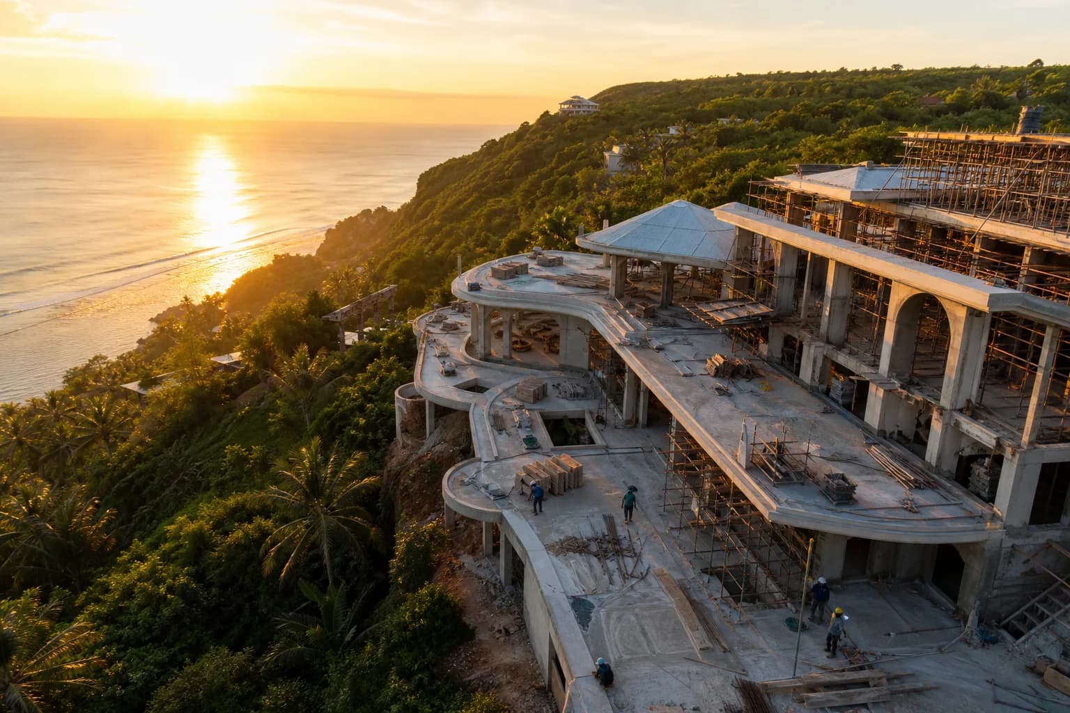
Purchasing cliff-edge land in Uluwatu presents a unique construction challenge that separates experienced developers from those who underestimate Bali’s coastal regulations. The question isn’t whether you can build on that spectacular cliff-front parcel—it’s whether your planned villa will comply with Indonesia’s 50-100 meter coastal setback requirements while maintaining structural integrity on unstable limestone formations. Without proper geotechnical surveys costing $3,500-$8,000 and engineering assessments of cliff stability, landslide risk, and sacred zone restrictions, your dream site can become an unbuildable asset. Uluwatu’s dramatic topography demands construction partners who understand both regulatory frameworks and the geological realities of building near eroding cliff edges where soil bearing capacity varies dramatically within meters.
Technical Framework: Uluwatu Cliff-Edge Setback Regulations and Geological Constraints
Uluwatu’s cliff-edge construction operates under multiple overlapping regulatory frameworks that create complex buildable zones. The primary coastal setback regulation (Peraturan Menteri) mandates 50-100 meters from the high tide mark or cliff edge, with the specific distance determined by local BAPPEDA (Regional Development Planning Agency) based on erosion rates and geological stability. However, this baseline measurement becomes complicated by Uluwatu’s limestone cliff formations, where the “edge” itself shifts due to ongoing erosion at rates of 10-30 centimeters annually in vulnerable sections.
The geological reality beneath Uluwatu’s dramatic vistas consists primarily of Bukit limestone—a porous, karstic formation with variable density and significant void spaces. This creates three critical construction challenges: unpredictable bearing capacity ranging from 150-400 kPa within the same parcel, differential settlement risks where foundation loads concentrate on weak zones, and progressive cliff retreat that can accelerate near structures due to altered drainage patterns. Properties within 200 meters of cliff edges require mandatory geotechnical investigations under Indonesian construction standards (SNI 8460:2017), yet enforcement remains inconsistent.
Temple setback regulations add another layer of complexity specific to Uluwatu. The iconic Uluwatu Temple (Pura Luhur Uluwatu) establishes sacred zones extending 100-500 meters depending on temple classification and local adat (customary law) interpretations. These zones prohibit construction above certain heights (typically 15 meters) and may restrict building orientations, roof styles, and even construction timing around ceremonial periods. Unlike coastal setbacks measured from physical features, temple setbacks involve consultation with local banjar (community organizations) and pemangku (temple priests), creating approval timelines of 3-6 months beyond standard permitting.
The intersection of these regulations creates what engineers call “constrained buildable envelopes”—the three-dimensional space where construction is legally and structurally feasible. On a typical 2,000-square-meter Uluwatu cliff-edge parcel, coastal setbacks might eliminate 40% of the land area, temple restrictions another 20%, and geological constraints (unstable zones, cavities, high-risk erosion areas) an additional 15%. The remaining 25% becomes your actual construction zone, often positioned awkwardly relative to access roads and view corridors. This reality explains why experienced Bali villa construction teams conduct feasibility studies before land purchase, not after.
Geotechnical survey requirements for cliff-edge sites extend beyond standard soil investigations. A comprehensive assessment includes: seismic refraction surveys to map subsurface limestone density and void locations ($1,200-$2,500), cone penetration testing (CPT) at multiple points to establish bearing capacity profiles ($800-$1,500 per location), cliff stability modeling using limit equilibrium analysis ($2,000-$3,500), and groundwater flow assessment to predict erosion acceleration ($600-$1,200). Total investigation costs for a single cliff-edge parcel typically range $5,500-$8,500, with higher costs for larger sites or areas with complex geology requiring additional test points.
Hidden Risks: What Cliff-Edge Land Buyers Consistently Underestimate
The most expensive mistake in Uluwatu cliff-edge development is purchasing land based on visual assessment and seller representations without independent verification of buildable area. Sellers frequently market parcels as “cliff-front with ocean views” while omitting that 70% of the land falls within restricted setback zones. The legal description may show 1,500 square meters, but only 450 square meters proves buildable after applying coastal, temple, and geological constraints. This discovery typically occurs during the IMB (building permit) application process, 6-12 months after purchase, when architectural plans get rejected for setback violations.
Cliff stability assessments reveal risks invisible during site visits. Uluwatu’s limestone undergoes continuous dissolution from rainfall and sea spray, creating subsurface cavities that migrate inland over decades. A geotechnical investigation on a Pecatu cliff-edge site in 2024 discovered a 4-meter void 18 meters from the cliff edge—directly beneath the planned villa footprint. Remediation required soil grouting and relocated foundations, adding $45,000 to construction costs. Without pre-construction surveys, these discoveries occur during excavation, triggering expensive design changes and construction delays of 2-4 months.
Temple setback negotiations involve cultural protocols that foreign buyers often mishandle, creating permanent development restrictions. A 2023 case involved a developer who began construction within 150 meters of a smaller temple without proper banjar consultation. The local community obtained a construction halt order, and resolution required ceremonial offerings, formal apologies, and design modifications reducing building height from 12 meters to 9 meters—eliminating the planned third-floor ocean view rooms. The 7-month delay and redesign costs exceeded $60,000, far more than the initial consultation process would have cost.
Step-by-Step Process: Navigating Cliff-Edge Construction from Land Assessment to Foundation
Phase 1: Pre-Purchase Technical Due Diligence (4-6 weeks)
Before committing to cliff-edge land, commission an independent feasibility study combining regulatory research and preliminary geological assessment. This involves obtaining the official site plan (rencana tata ruang) from the local BAPPEDA office to verify zoning designation and documented setback requirements—costs typically $200-$400 including translation. Engage a licensed geotechnical consultant to conduct a desktop study reviewing regional geology, historical erosion data, and nearby site investigations, providing preliminary risk assessment for $800-$1,200. Simultaneously, consult with the local banjar to identify temple setback requirements and cultural restrictions, a process requiring a local facilitator familiar with adat protocols ($300-$600 facilitation fee).
This phase should produce a buildable area map overlaying all restrictions, showing the realistic construction envelope before purchase negotiations. If the buildable area proves insufficient for your program requirements, you’ve invested $1,500-$2,500 to avoid a $200,000+ land purchase mistake. Experienced construction partners like Teville’s land consultation service integrate this analysis into their verified land offerings, pre-screening parcels for construction feasibility.
Phase 2: Comprehensive Geotechnical Investigation (3-4 weeks)
After land acquisition, commission the full geotechnical survey before architectural design begins. The investigation should include minimum three CPT test points for parcels under 1,000 square meters (five points for larger sites), positioned to sample the buildable envelope and areas near the cliff edge. Seismic refraction surveys should map subsurface conditions to 15-20 meters depth, identifying voids, weak zones, and bedrock depth variations. Cliff stability modeling must calculate factor of safety under static and seismic loading, considering both current conditions and projected erosion over a 50-year building lifespan.
The geotechnical report should provide specific foundation recommendations—whether shallow footings prove adequate (rare on cliff-edge sites), or whether deep piles, caissons, or ground improvement becomes necessary. This document becomes the basis for structural engineering and directly impacts villa construction cost estimates, as foundation systems can range from $15,000 for simple footings to $80,000+ for deep pile systems on unstable ground.
Phase 3: Integrated Design and Permit Strategy (8-12 weeks)
Architectural design for cliff-edge sites must integrate geotechnical constraints from the first sketch, not treat them as afterthoughts. The structural engineer should participate in early design reviews, ensuring building loads align with soil bearing capacity and foundation locations avoid identified weak zones. Building orientation and massing must respect temple setback requirements while maximizing ocean views within the constrained envelope—often requiring creative solutions like split-level designs or cantilevered viewing platforms that extend visual access without violating setbacks.
The IMB application for cliff-edge construction requires additional documentation beyond standard permits: the geotechnical investigation report with licensed engineer certification, cliff stability analysis demonstrating adequate safety factors, drainage plans showing how construction won’t accelerate erosion, and temple setback approval letters from relevant banjar organizations. This documentation package typically adds 3-4 weeks to standard permit timelines, with total approval processes ranging 4-6 months for cliff-edge sites versus 3-4 months for standard inland parcels.
Phase 4: Foundation Construction and Monitoring (6-10 weeks)
Cliff-edge foundation work demands enhanced quality control and monitoring protocols. Excavation should proceed with geotechnical observation to verify subsurface conditions match investigation predictions—discovering unexpected voids or weak zones during digging is common and requires immediate engineering assessment. Foundation installation near cliff edges may require temporary shoring or ground stabilization to prevent excavation-induced instability. Post-construction monitoring systems, including settlement markers and crack monitoring points, should be installed to track long-term performance, particularly for structures within 75 meters of cliff edges where ongoing erosion creates evolving load conditions.
Realistic Cost Ranges and Timeline Expectations for Uluwatu Cliff-Edge Projects
Geotechnical investigation costs for Uluwatu cliff-edge sites break down as follows: basic soil investigation with three CPT points and laboratory testing ($2,500-$3,500), seismic refraction survey for subsurface mapping ($1,200-$2,500), cliff stability analysis and modeling ($2,000-$3,500), and groundwater assessment ($600-$1,200). Comprehensive packages from reputable Indonesian geotechnical firms range $5,500-$8,500 for standard residential parcels, with costs increasing for larger sites or complex geology requiring additional test points.
Foundation cost premiums for cliff-edge construction typically add 40-120% versus inland sites. A standard villa foundation on stable inland soil might cost $18,000-$25,000, while the same building on a cliff-edge site could require $35,000-$55,000 due to deeper foundations, ground improvement, or specialized pile systems. Extreme cases involving significant voids or very weak zones can push foundation costs to $70,000-$90,000 for a 300-square-meter villa. These costs directly impact overall villa construction budgets, making pre-purchase geological assessment critical for accurate financial planning.
Timeline extensions for cliff-edge projects add 2-4 months to standard construction schedules. Pre-construction investigations add 4-6 weeks, enhanced permit documentation another 3-4 weeks, and foundation work with geological monitoring typically requires 2-3 weeks longer than standard construction. Total project timelines for cliff-edge villas range 14-18 months from land purchase to completion, versus 10-12 months for comparable inland projects. Buyers should budget both financial and time contingencies of 15-20% above standard project estimates.
Frequently Asked Questions: Uluwatu Cliff-Edge Construction Specifics
Can I build right up to the cliff edge if I own the land to the boundary?
No. Indonesian coastal regulations mandate 50-100 meter setbacks from cliff edges regardless of property boundaries, with specific distances determined by local BAPPEDA based on erosion rates and geological stability. The setback measurement typically starts from the cliff edge or high tide mark, whichever is more restrictive. Violations result in permit denial, construction halt orders, or demolition requirements. Even if existing structures appear closer to edges, they may predate current regulations or represent unpermitted construction. Always verify buildable setbacks through official BAPPEDA consultation before purchase, as seller representations frequently prove inaccurate.
How much does a geotechnical survey actually cost for a typical Uluwatu cliff-edge parcel?
Comprehensive geotechnical investigations for cliff-edge residential sites range $5,500-$8,500 from licensed Indonesian firms, covering soil testing, subsurface mapping, cliff stability analysis, and foundation recommendations. Basic investigations with minimal testing might cost $3,000-$4,000 but often prove inadequate for permit approval or safe design. Larger parcels or sites with complex geology requiring additional test points can reach $10,000-$12,000. This investment is essential—attempting to skip or minimize geotechnical work on cliff-edge sites creates liability risks and typically results in expensive surprises during construction when problems are far more costly to address.
What happens if the geotech
Want to calculate?
 3127 m²9 month(s)from 177.000 USD
Mukunda
 3124 m²6 month(s)from 123.000 USD
TALA 8
 3173 m²6 month(s)from 125.000 USD
TALA FOUR
 3180 m²7 month(s)from 142.000 USD
Vasudeva
 2144 m²11 month(s)from 104.000 USD
Narayana
 164 m²7 month(s)from 79.000 USD
TALA TWO
 172 m²8 month(s)from 120.000 USD
Keshava
 1from 198.000 USD
Private: Haridas Villas
164 m²7 month(s)from 79.000 USDPrivate: Haridas Villas, Tegallalang
 3104 m²11 month(s)from 99.000 USD
TALA 100
 4344 m²16 month(s)from 290.000 USD
Radha
Start With Real Numbers, Not Guesses
Before buying land or finalizing a design, check the realistic build cost range for your project in Bali.
Our team reviews your inputs and gives a grounded estimate.
Available lands
 18900 m²2 min$ 6912931Bali, Pecatu
 700 m²15 min$ 162500Bali, Tabanan
 800 m²5 min$ 295567Bali, Seseh
 608 m²15 min$ 310377Bali, Seminyak
 1300 m²10 min$ 348214Bali, Tabanan
 4270 m²10 min$ 394397Bali, Ubud
 1350 m²5 min$ 283467Bali, Pecatu
 960 m²15 min$ 91034Bali, Mengwi
 2500 m²5 min$ 609606Bali, Kedungu
 2200 m²3 min$ 183842Bali, Berawa
 2115 m²5 min$ 1139547Bali, Pererenan
 2000 m²15 min$ 523000Bali, Canggu
 10000 m²19 min$ 232759Bali, Buleleng
 3000 m²15 min$ 738916Bali, Cepaka
 29000 m²6 min$ 3857143Bali, Tabanan
Planning a build in Bali?
Get a feasibility view, budget range and timeline from Teville.
Related guides
Resin-Infused Plaster Finishes: Anti-Salt Systems Bali
Expert technical guide: Resin-Infused Plaster Finishes: Anti-Salt Systems Bali
8 min read
Prefinished Timber Joinery: Silicone Seals Fixings Bali
Professional prefinished timber joinery installation in Bali with silicone seals and fixings for durable weatherproof performance and a premium finish.
10 min read
Polished Concrete Microtopping: Surface Prep Sealants Bali
Discover Bali s polished concrete microtopping: expert surface prep, durable sealants, and a flawless finish for modern floors with minimal maintenance.
9 min read